http://www.theatlanticcities.com/technology/2012/05/how-smart-phones-are-turning-our-public-places-private-ones/2017/
The more fundamental question to ask is what was left of our public spaces when smart phones arrived on the scene? Public space in American cities was already heavily restricted from social interaction before the technology arrived. People were crammed onto narrow sidewalks, barricaded on one side by parked cars and roaring traffic and on the other by shops (or just walls) and eateries that were unlikely to host any outdoor seating. Even the few places that were explicitly dedicated to the public, urban parks and plazas, were by-in-large underutilized in comparison to the successful versions in Europe, where a culture of "living" in public space and more pleasant urban form prevails. I've lived in Boston, New York City, and the San Francisco Bay Area in the last year. I've lived near exemplary public spaces, such as Bryant Park and Boston Common and beautiful parks in San Francisco, Oakland, and Berkeley. People make good use of these spaces. They congregate with friends, run into acquaintances, and even meet new people. The Smart phones are as much about coordination with people and events as they are a distraction when there is nothing better to do. It's true that we might look up directions on Google instead of asking someone, but there are a lot of new social activities enabled by the phones, such as finding out that a meetup.com or some other topical social group is meeting nearby. It's also much easier to spontaneously schedule get-togethers with the combination of texting, calling, and Internet.
I think that smart phones filled a void in a delinquent public space culture. It's true that you will find peoples' noses buried in their smart phones in Europe's best places, but you'll also find thousands of outdoor cafés where smart phones are just a small piece of the action. No doubt the smart phones are lamented by some people in Europe as well, but on either continent it's the wrong axe to grind. The real enemy of public space is foremost cars, and secondly the corporate driven message that the purpose of public space is to get you from one place of consumption to another. What public space should be is a beautiful and safe place (i.e. no asphalt) where people meet and do creative things together. This can be conversation or bocci ball or musical improv. I just started reading The Great Escape by Kati Martin that chronicles the lives of nine extraordinary Hungarian Jews that all grew up in pre-World War I Budapest. They all drank in a culture of art, science, and (short-lived) freedom that was devoured by fascism and communism. It's no surprise that this golden age in Hungary happened pre-car, because so much of it was enabled by the physical form of the city.
So no more complaining about new technology when things were already so messed up. We have a huge opportunity to improve public space in part because of the opportunities enabled by smart phones. It's easier to use transit and participate in the sharable economy--where we share transportation, lodging, tools, and our time.
Monday, May 21, 2012
Sunday, May 13, 2012
UC Berkeley graduation day would not break a light rail system and pedestrian streets
There were more than the usual throngs on College Ave on a beautiful spring Saturday. Graduation day at Berkeley intensified activity, bringing in families from afar and moving vans to the abundant student housing on and near College Ave.
I checked the nearest bus stop real time data. It was due in 3 minutes about a quarter mile behind me. I started walking, thinking to pick it up after the normal traffic jam a the Ashby Ave intersection. But conditions caused me to keep walking all the way to UC Berkeley, well over a mile. I could have made it to downtown Berkeley before the besieged bus caught up. After boarding we crawled to BART and released our jam-packed load, only to be stuck in traffic all the way down University Ave to route's end.
This is the reality of bus transit and car clogged mixed use streets. The buses can't function--they are too small to handle crush loads, especially when they get behind schedule. But they aren't important enough as a percentage of travelers to warrant dedicated lanes on a narrow street like College Ave or a four lane arterial like University. Nor are they carry enough passengers to warrant giving them signal priority at intersections, which doesn't help during a traffic jam anyway. The chicken and egg problems requires a dual solution to kill two birds with two stones. Light rail must be introduced in tandem with narrow street pedestrianization and dedicated lanes on arterials. I firmly believe that this is the only way to fix public space and transit in successful mixed use neighborhoods. Cities all over Europe have figured this out. You can build an underground metro at high cost to solve the transit problem, but you won't solve the public space problem. Richard Bergeron of Projet Montréal was the first person I heard advocate the tramway (streetcar or light rail or a hybrid thereof) over metro to improve public space, and he is absolutely right. I'd go as far to say that anywhere that has enough population for metro service also needs light rail on the surface streets to improve public space and cover the territory just missed by the metro.
The problem is obvious, the solutions are becoming clearer. But what is the implementation for a complete light rail and pedestrian street network that can be fully funded as needed by charging much more for car use (to redirect all that money currently wasted on burning oil) and government incentives? We can make drivers fund transit with a combination of mileage and pollution fees that go to the city or region for the project. We can consolidate parking with incentive programs geared at privately owned lots, like those of banks and grocery stores, and then increase parking costs continually while we remove spots to hold revenue neutral. We can give renters and property owners along a proposed route big incentives to give up driveway access on a yearly basis in exchange for car-share vouchers or at worst car storage in a lot or dedicated street space nearby.
I think UC Berkeley graduation day is a great litmus test for my public space and transportation overhaul of the East Bay. I'll need to face the realities of moving vans, hundreds of thousands of visitors concentrated within just a couple miles worth of streets, and all the other related challenges that a good system must handle gracefully. Our current system certainly failed.
Tuesday, May 8, 2012
The silliness of UC Berkeley's vocalized bus turn alerts
On my bike route to the office this morning, I was delighted to hear a new UC Berkeley shuttle bus that services the university labs up in the hills announce by computer voice that it was turning. The message is something to the effect of "Pedestrians, bus is turning".
Here's the UC Berkeley announcement about the buses, where I left the following comment:
http://today.lbl.gov/2012/03/07/lab-shuttles-now-feature-safe-turn-alert-for-pedestrian/comment-page-1/#comment-593544
I admit then that BRT (bus rapid transit), if it could be built to full BRT standards (it never is in this country), would remove a lot of the unpredictability and therefore danger of buses. The problem with BRT though, even with Class B right-of-way (dedicated lanes exposed to traffic at intersections), is that there remains an unsettling driver unpredictability. I'm sure that bus drivers with their own lanes drive better, especially when the bus has to needle its way through a tunnel like the poor Boston MBTA Silver Line to the airport. But inevitably the driver has the ability to accelerate to make green lights or to speed up and slow to keep with their schedule. The best we can do is to reduce to variability of our surface transit vehicles by simply putting them on tracks on dedicated lanes in the street. Nobody ever has to worry about an aggressive streetcar or light rail driver, at least not in this century. The vehicles are technically capable and should always travel at the exact same speed through each segment of their route. They must always make turns slowly due to their articulated body and the limiting characteristics of rail, making it nearly impossible for a pedestrian or cyclist to be caught off-guard. BRT buses could have set speeds as well, but they typically leave the driver in control, both to save costs on technology and because the driver has to control the steering wheel of the bus anyway.
All of my posts on BRT versus light rail and the merits of pedestrianizing streets revolve around the same theme: We can't make decisions about transit modes and our use of streets with purely quantitative reasoning. The reason to pedestrianize and use rail or bus has numerous qualitative benefits that require detailed discussion.
Here's the UC Berkeley announcement about the buses, where I left the following comment:
http://today.lbl.gov/2012/03/07/lab-shuttles-now-feature-safe-turn-alert-for-pedestrian/comment-page-1/#comment-593544
...The announcement begins while the bus in making the turn, so the only warning the pedestrian receives is the start of the word “pedestrians” before the bus is intersecting their path. If UC Berkeley wants to make the streets safer, it should support policies to pedestrianize streets and and reintroduce streetcars/lightrail to Berkeley, the only form of transit that is completely predictable. The Ecocity Builders have had a great plan to pedestrianize the single block of Center St. between campus and BART for years (http://ecocitybuilders.org/projects/current/center-street-plaza/).As an urban society, we continue to endure quick fixes that are useless to solving overarching problems. The reason that buses are dangerous is that they are unpredictable. As bikers we don't know when they are going to pull over to pick up passengers, unless we are familiar with all the stops. As bikers and pedestrians we don't know when they will turn, unless we are familiar with the route. They regularly play leap frog with bikers because our overall speeds match, leading to the biker passing the bus at a stop and the bus passing a biker on a long straightaway. Most of these problems would be solved with a dedicated transit right-of-way. The bus wouldn't pull over for stops, and it would be fairly obvious where it was turning unless there was a route junction.
I admit then that BRT (bus rapid transit), if it could be built to full BRT standards (it never is in this country), would remove a lot of the unpredictability and therefore danger of buses. The problem with BRT though, even with Class B right-of-way (dedicated lanes exposed to traffic at intersections), is that there remains an unsettling driver unpredictability. I'm sure that bus drivers with their own lanes drive better, especially when the bus has to needle its way through a tunnel like the poor Boston MBTA Silver Line to the airport. But inevitably the driver has the ability to accelerate to make green lights or to speed up and slow to keep with their schedule. The best we can do is to reduce to variability of our surface transit vehicles by simply putting them on tracks on dedicated lanes in the street. Nobody ever has to worry about an aggressive streetcar or light rail driver, at least not in this century. The vehicles are technically capable and should always travel at the exact same speed through each segment of their route. They must always make turns slowly due to their articulated body and the limiting characteristics of rail, making it nearly impossible for a pedestrian or cyclist to be caught off-guard. BRT buses could have set speeds as well, but they typically leave the driver in control, both to save costs on technology and because the driver has to control the steering wheel of the bus anyway.
All of my posts on BRT versus light rail and the merits of pedestrianizing streets revolve around the same theme: We can't make decisions about transit modes and our use of streets with purely quantitative reasoning. The reason to pedestrianize and use rail or bus has numerous qualitative benefits that require detailed discussion.
Thursday, February 23, 2012
Optimizing Transportation and Public Space
My thoughts have been on two major projects lately. The first, California High Speed Rail, is real and fighting to overcome deep misunderstandings about its primary purposes. The second project, a master plan to optimize East Bay (Oakland, Berkeley, and their environs) transportation and public space, is still all in my head. I'd like to give some thoughts on High Speed Rail and then I'll talk about the East Bay master plan in another post.
High speed rail in America is mistakenly believed to be primarily intended as a high speed, high cost rail line that connects Northern and Southern California's large population centers. This mistake is made because no part of that statement is technically false. The confusion lies in neglecting the more important purposes of the rail network, which are numerous. The most important purposes of the rail network are as follows, in decreasing priority:
1. High Speed Rail forms the trunk line of a multi-modal (rail, plane, car, boat, bike, feet, etc.) network that moves people more efficiently (in terms of time, space, resource consumption, and externalities) than anything else in existence.
2. High Speed Rail makes it possible to travel the state in all urban areas without use of a car--the most inefficient and destructive mode of transportation. Previously only some major cities could be traveled within or between in travel times competitive with a car by using a combination of plane, rail, bike, and feet.
3. High Speed Rail provides the trunk line that connects every transit system in the state. People who are willing to use high speed rail are typically also willing to use all forms of transit except buses (possible exceptions are buses with separated right-of-way and free shuttles.) This means that high speed rail turns dozens of disconnected systems into a unified system and creates a positive feedback loop to improve those systems and raise ridership. Since high speed rail riders will depart and arrive in cities with insufficient transit, such as Redwood City, Fresno, Bakersfield, and Anaheim, new non-bus transit systems will need to be built to accommodate them and thus make the state's urban transportation network comprehensive.
4. High Speed Rail corrects major deficiencies in a metropolitan regional rail system. For instance, it enables the fastest possible travel times between cities such as San Francisco and San Jose or Los Angeles and Bakersfield. Currently those cities are served by deficient regional rail (or none in the latter case) that is only competitive with driving at certain times, such as commute hours.
5. High Speed Rail makes use of a car only necessary in non-urbanized or very low density suburbs, which are the only places that cars are most efficient and suitable for everyday travel.
The primarily imagined purpose of high speed rail does not make the top 5 list. It's very important to move people between LA/San Diego and San Francisco/Sacramento in 2 or 3 hours in order to make the system competitive with flying. By decreasing flying we make large gains in efficiency in terms of reduced dirty energy usage and externalities, but the time and space savings are minor. It is also important in that it allows the system to generate an operational profit, which is typical of high speed rail. Since people fixate on high speed rail as the flying alternative, they start improperly conflating the cost of building the system and inconveniencing property owners with the cost of maintaining commercial flights, whose capital costs are long since sunk or hidden from the public. They therefore start thinking of the $100 billion dollar price tag as something better spent on schools, even though none of the state, federal, or private investment would have ever been spent on schools or any other similar investment.
If you need to explain high speed rail to someone, start with the Internet. Back in the '90s, we had slow dial-up connections. There were trunk lines for moving lots of data but we were all bottlenecked by the telephone lines. Then we got high bandwidth connections at home via cable and DSL. In order for us all to have those high speed connections, the trunk lines around the country and world had to be continuously improved and duplicated. In terms of transportation, the car is like having a cable connection with no high speed trunk lines. It's true that you can drive to the airport or drive the whole distance, but neither scale efficiently. Metropolitan transit systems on dedicated right-of-way (typically rail) and high speed rail scale much better than cars and planes and happen to work really well together, since the trains of one system can meet those of the other without requiring enormous parking lots or runways. Using the same analogy, it's not that important to be connected "directly" to a trunk line on the Internet and accessing something that is also "directly" connected to a trunk line, unless you're transmitting insane amounts of data. It's enough that the trunk lines exist and you have a decent cable connection to move your data to and from them. In terms of transit, it's not that important to live right at the Transbay Terminal in San Francisco and take high speed rail to a meeting right next to Union Station in Los Angeles. What's important is that the high speed rail line exists with quality metropolitan transit so that you can use the two together and live in any urban area in the state. Being able to travel the urban areas of the state without a car and planes is essential to handling the limits of our growing population and finite resources, and it makes life better.
Monday, January 23, 2012
Does High Speed Rail diminish living local?
Most people tend to live in places that allow them to get to work in
around a half-hour, with an hour being the outer edge of tolerance
before we get into the outliers. One argument that high speed rail
critics lob at the proposed project in California is that will reduce
local living and actually encourage sprawl by allowing people to live
farther from work.
Let's consider then the difference between a car and train based commute for people who commute to a downtown business center such as San Francisco. A major suburb or satellite city lies 50 miles from the main city center, and a small city lies 100 miles from the main city center. Let's assume that the driver can average 60 mph on the main freeway and that the train can average 150 mph (this is a liberal estimate, considering that much of the time would be spent within 50 miles of the city center, where speeds are typically slower.) I'll compare those that drive to those that use a combination of train and walking or biking. I'll address the hybrid case after.

The green areas represent the places that people can live in order to commute to downtown in the main city. In the car case they can live anywhere within an hour's drive where roads exist. The drivers are able to sprawl fifty miles from the city center and sprawl ten to twenty miles in the suburb or satellite city (depending how close they are to a freeway) and still make it to work in around an hour or less (assuming there isn't horrible traffic, which there often is.)
Now examine the combination of high speed rail and regional rail, and subways or light rail downtown. Outside the downtown area, the rail riders are limited to small green population centers within a maximum 5 miles of a train station, whether it's high speed rail or a regional rail station that connects to high speed rail. However, the rail users are also permitted to live within 5 miles of the small city that is a 100 miles from the main city's center. The hundred mile commute from the small city will reasonably take around an hour to walk about 10 minutes to and from each station and take the 40 minute ride. Although drivers can't drive from the small city in an hour, it's hard to say that living within 5 miles of the small city's train station is sprawl, especially since the majority will need to live within 1 mile of the station to walk. Moreover, since all the rail users walk or bike to a station in their neighborhood to reach the train, it's certain that they live more "locally" than those who drive directly from their homes to the main city center without walking any local streets.
The high speed rail critic will now site the hybrid case as the reason that high speed rail causes sprawl. Imagine if a commuter used a car to access a high speed rail station to get to work? Where else could they live in the rail diagram above? They could live reasonably within ten miles of the high speed rail station in the suburb or satellite city by doing the following: 1) A 10 minute drive to the station (if they had uncongested highways); 2) Plus 10 minutes to park and catch the train (realistic given that the they'd have to drive into a parking garage, take the stairs, walk to the platform, and wait for the train, which is harder to time when driving than walking; 3) Plus 20 minutes on the train to go 50 miles; 4) About 10 minutes to walk to their final destination. Thus, it takes a minimum 50 minutes if all goes well to get to work if living 10 miles from the suburban station, which is how long it takes to simply drive directly to work if they live on the closer side of the suburb. Living in the small city 100 miles away and driving to the station would take over an hour if you add 20 minutes to the above calculation to travel the extra 50 miles. The hybrid scenario greatly increases the chance of unexpected delays, since commuters are subject to the incidents of both driving on highways and the train. Thus, the sprawl added by high speed rail when people drive to the station looks like this:

That yellow area on the far side of the suburb or satellite city is the only contribution to sprawl that high speed rail can make. You can live an extra 5 miles away from the city center and keep your commute to about an hour. It wouldn't be realistic to drive more than 10 miles to the regional rail station in the suburb or satellite city, nor to drive more than 5 miles in the small city, to access the high speed rail network. The time penalties of driving to a station, parking in a garage, and getting to platform are significant.
My conclusion is that high speed rail can't do much for sprawl, except for the outliers willing to commute over an hour, and remember that a 30 minute commute is average in most places. The sprawl that is enabled in the the yellow area above is still a difficult commute given that two different motorized modes of transit must be relied upon. I bet it would be hard to drive more than 10 miles to that suburban high speed rail station and make it to work reliably in an hour.
On the other hand, high speed rail can do a lot for living locally. It gives regional rail and light rail a backbone to connect to, so that anyone living within walking or biking distance of any rail station can commute to the main city's downtown in a reasonable amount of time. It's a lot easier to time a regional rail to high speed rail transfer than a car to high speed rail transfer, because the schedules are designed for it. Also, all that time on trains is time that can be spent working, which allows some commuters to get work done on board instead of at the office. As long as all the trains in the network give everyone a seat to work, rest, or sleep in, the time on the train is productive (metro and light-rail should never be standing room only.) The productivity of train commuting can actually give people more time at home or hanging out in their neighborhood. And the driver will inevitably bypass their local business district in favor of something convenient near the freeway in order to do errands or spend leisure time.
Let's consider then the difference between a car and train based commute for people who commute to a downtown business center such as San Francisco. A major suburb or satellite city lies 50 miles from the main city center, and a small city lies 100 miles from the main city center. Let's assume that the driver can average 60 mph on the main freeway and that the train can average 150 mph (this is a liberal estimate, considering that much of the time would be spent within 50 miles of the city center, where speeds are typically slower.) I'll compare those that drive to those that use a combination of train and walking or biking. I'll address the hybrid case after.
The green areas represent the places that people can live in order to commute to downtown in the main city. In the car case they can live anywhere within an hour's drive where roads exist. The drivers are able to sprawl fifty miles from the city center and sprawl ten to twenty miles in the suburb or satellite city (depending how close they are to a freeway) and still make it to work in around an hour or less (assuming there isn't horrible traffic, which there often is.)
Now examine the combination of high speed rail and regional rail, and subways or light rail downtown. Outside the downtown area, the rail riders are limited to small green population centers within a maximum 5 miles of a train station, whether it's high speed rail or a regional rail station that connects to high speed rail. However, the rail users are also permitted to live within 5 miles of the small city that is a 100 miles from the main city's center. The hundred mile commute from the small city will reasonably take around an hour to walk about 10 minutes to and from each station and take the 40 minute ride. Although drivers can't drive from the small city in an hour, it's hard to say that living within 5 miles of the small city's train station is sprawl, especially since the majority will need to live within 1 mile of the station to walk. Moreover, since all the rail users walk or bike to a station in their neighborhood to reach the train, it's certain that they live more "locally" than those who drive directly from their homes to the main city center without walking any local streets.
The high speed rail critic will now site the hybrid case as the reason that high speed rail causes sprawl. Imagine if a commuter used a car to access a high speed rail station to get to work? Where else could they live in the rail diagram above? They could live reasonably within ten miles of the high speed rail station in the suburb or satellite city by doing the following: 1) A 10 minute drive to the station (if they had uncongested highways); 2) Plus 10 minutes to park and catch the train (realistic given that the they'd have to drive into a parking garage, take the stairs, walk to the platform, and wait for the train, which is harder to time when driving than walking; 3) Plus 20 minutes on the train to go 50 miles; 4) About 10 minutes to walk to their final destination. Thus, it takes a minimum 50 minutes if all goes well to get to work if living 10 miles from the suburban station, which is how long it takes to simply drive directly to work if they live on the closer side of the suburb. Living in the small city 100 miles away and driving to the station would take over an hour if you add 20 minutes to the above calculation to travel the extra 50 miles. The hybrid scenario greatly increases the chance of unexpected delays, since commuters are subject to the incidents of both driving on highways and the train. Thus, the sprawl added by high speed rail when people drive to the station looks like this:
That yellow area on the far side of the suburb or satellite city is the only contribution to sprawl that high speed rail can make. You can live an extra 5 miles away from the city center and keep your commute to about an hour. It wouldn't be realistic to drive more than 10 miles to the regional rail station in the suburb or satellite city, nor to drive more than 5 miles in the small city, to access the high speed rail network. The time penalties of driving to a station, parking in a garage, and getting to platform are significant.
My conclusion is that high speed rail can't do much for sprawl, except for the outliers willing to commute over an hour, and remember that a 30 minute commute is average in most places. The sprawl that is enabled in the the yellow area above is still a difficult commute given that two different motorized modes of transit must be relied upon. I bet it would be hard to drive more than 10 miles to that suburban high speed rail station and make it to work reliably in an hour.
On the other hand, high speed rail can do a lot for living locally. It gives regional rail and light rail a backbone to connect to, so that anyone living within walking or biking distance of any rail station can commute to the main city's downtown in a reasonable amount of time. It's a lot easier to time a regional rail to high speed rail transfer than a car to high speed rail transfer, because the schedules are designed for it. Also, all that time on trains is time that can be spent working, which allows some commuters to get work done on board instead of at the office. As long as all the trains in the network give everyone a seat to work, rest, or sleep in, the time on the train is productive (metro and light-rail should never be standing room only.) The productivity of train commuting can actually give people more time at home or hanging out in their neighborhood. And the driver will inevitably bypass their local business district in favor of something convenient near the freeway in order to do errands or spend leisure time.
Wednesday, January 11, 2012
On the grandeur of train travel
Reading transit blogs typically leaves something to be desired because the transit experts who write them have been steadfastly trained to care about numbers--shaving minutes off trips, saving a billion on a rail project by bypassing a town center, optimizing cost-per-rider, etc. There are people who care about more than that, but they are by and large the millions of people that ride transit and not the ones analyzing the numbers. This leads me to discuss a couple of transit topics in the context of grandeur, not numbers.
Rail versus bus service on city streets
I've analyzed the qualitative differences between rail service and bus rapid transit (BRT) before, but given the sustained interest in BRT where I live in the Bay Area, I want to spend one more moment on it. Here are a few pictures of BRT lines in North America from Wikipedia. It's a somewhat random sample, based on systems for which I could quickly find imagery. I hope I'm being fair in showing typical BRT systems in North America.

Now I want to show you a few examples of impressive street-based rail systems in North America, based solely on appearances:
 What's the difference between our typical BRT implementations and the best of our streetcar/light-rail (and our lone cable car) systems? Well for one thing, the cars last a long time and are loved enough to maintain them in service for upwards of a hundred years. The systems with new fleets are impressive too. They are sleek, graceful, and in some cases the scene of them traversing a resurfaced street is downright beautiful (it's hard to disagree when you look at the European examples.) I think the real difference is the pursuit of grandeur, for lack of a better word. Whether we pay $10 or $100 million per mile of dedicated transit right-of-way in the city does matter, but it's possible to pay too little and miss out on the grandeur that is within reach. I think the BRT examples lack any bit of grandeur, whereas many of the streetcar/light-rail/cable car examples above achieve it. When I hear talk of putting BRT on Van Ness Ave in San Francisco, or on Telegraph Ave in Oakland, I hang my head low, because I know the people making the decisions are those who don't recognize the potential for grandeur in our streets.
Can modern regional rail, and even subways, have grandeur?
I stood on the BART platform in the Rockridge neighborhood of Oakland this morning. This is the best representation of it that I could find online:

There's no grandeur in waiting on a freeway platform or in sitting in a BART train. The cushioned seats on the trains are about the only thing going for it, and those will be removed in the next ordered train set owing to media-hyped findings of dangerous bacteria. Typical not-so-grandiose factors to consider when choosing to ride most modern regional/commuter trains and subways are: platforms on freeways or in dreary underground caverns, crowded and dirty cars, uncomfortable seats (if available at all), harsh fluorescent lighting, loud ventilation fans, loud track noise in tunnels (seems to be mostly a BART problem), and complete lack of good behavioral enforcement (since no officials besides the driver are on the train.) Certainly, our train systems have a lot of functional problems relating to infrequency, underdeveloped networks, and sometimes a lack of express service where clearly warranted. The transportation bloggers would love to fix these problems, and figure out how to do it with maximum efficiency. While we do that might we also achieve grandeur on our regional trains and subways? I think so.


Subways, including BART, which functions as both a regional train and metro, typically lack everything described above. Why is that? There are some subway routes that are packed downtown. There's simply no way to run enough trains to give everyone a seat at the downtown stations, nor does anyone really need a seat to go three stops downtown. That suggests to me that subway cars should probably be configured for people traveling long distances and for people doing short hops. Boston's Red Line implemented Big Red trains with standing room only and positions them as the middle cars of trains during commute hours. I would agree with their strategy if they were actually meant for short-hop travelers downtown, but they were really implemented to cram more people into the trains at rush hour, whether they are traveling thirty minutes or five. What if we configured standing room-only cars in the middle of our subways but placed plush seats and cafe cars on the ends? Many trips on BART or subway in NYC are over thirty minutes in length, which makes the AMTRAK configuration (including restrooms) very practical. A cursory search for luxury subway cars leaves much to be desired. This was BMW's effort at a luxurious recyclable subway in Poland:

It advertises soft lighting, individually-controlled climate control per car, and wide doors. It looks much more like the subway cars I already know than a comfortable sitting space with amenities.
I think what we need to do is to start treating our subways with the same type of grandeur that used to be applied to passenger trains. It doesn't require caviar nor private compartments, it just means taking the practical comforts of trains and adapting them to the size and larger passenger loads on subways. It's a two-way street--make the subway more like a comfortable train car and reduce the overcrowding and arbitrary mixing of short and long-haul riders in each car. It of course requires running higher frequencies, new cars, on board attendants, expanding networks--in short spending a lot more money on capital and operational costs. But we need to do many of those things anyway just to make transit usable. Let's get the cost and efficiency numbers in the right neighborhood, but then let's "waste" some money on grandeur. We might be surprised at what it does for the ridership numbers.
Rail versus bus service on city streets
I've analyzed the qualitative differences between rail service and bus rapid transit (BRT) before, but given the sustained interest in BRT where I live in the Bay Area, I want to spend one more moment on it. Here are a few pictures of BRT lines in North America from Wikipedia. It's a somewhat random sample, based on systems for which I could quickly find imagery. I hope I'm being fair in showing typical BRT systems in North America.
Now I want to show you a few examples of impressive street-based rail systems in North America, based solely on appearances:
Can modern regional rail, and even subways, have grandeur?
I stood on the BART platform in the Rockridge neighborhood of Oakland this morning. This is the best representation of it that I could find online:

There's no grandeur in waiting on a freeway platform or in sitting in a BART train. The cushioned seats on the trains are about the only thing going for it, and those will be removed in the next ordered train set owing to media-hyped findings of dangerous bacteria. Typical not-so-grandiose factors to consider when choosing to ride most modern regional/commuter trains and subways are: platforms on freeways or in dreary underground caverns, crowded and dirty cars, uncomfortable seats (if available at all), harsh fluorescent lighting, loud ventilation fans, loud track noise in tunnels (seems to be mostly a BART problem), and complete lack of good behavioral enforcement (since no officials besides the driver are on the train.) Certainly, our train systems have a lot of functional problems relating to infrequency, underdeveloped networks, and sometimes a lack of express service where clearly warranted. The transportation bloggers would love to fix these problems, and figure out how to do it with maximum efficiency. While we do that might we also achieve grandeur on our regional trains and subways? I think so.

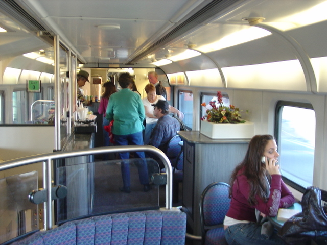
Above is AMTRAK Capitol Corridor, the regional/commuter train between Sacramento and San Jose. The interior is lovely and comfortable (and these trains have great ridership, despite the picture.) This certainly seems like a basic level of quality we can apply to any regional or commuter train: plush seats, a seat for everyone under normal commute conditions, cleanliness, soft lighting, and officials on board to enforce good behavior and help people. Capitol Corridor also features a snack car that sells coffee, beer, and basic food. Whether AMTRAK makes any money on this or loses money doesn't really matter--it's a really nice feature to have on any kind of transit:

It advertises soft lighting, individually-controlled climate control per car, and wide doors. It looks much more like the subway cars I already know than a comfortable sitting space with amenities.
I think what we need to do is to start treating our subways with the same type of grandeur that used to be applied to passenger trains. It doesn't require caviar nor private compartments, it just means taking the practical comforts of trains and adapting them to the size and larger passenger loads on subways. It's a two-way street--make the subway more like a comfortable train car and reduce the overcrowding and arbitrary mixing of short and long-haul riders in each car. It of course requires running higher frequencies, new cars, on board attendants, expanding networks--in short spending a lot more money on capital and operational costs. But we need to do many of those things anyway just to make transit usable. Let's get the cost and efficiency numbers in the right neighborhood, but then let's "waste" some money on grandeur. We might be surprised at what it does for the ridership numbers.
Saturday, December 31, 2011
Tweaking performance of Rescape
As I attempt to make an official beta release of Rescape, I've been struggling mightily with getting the software to work under the Windows version of Sketchup because it's harder to work with external libraries than it is on OS X. I've also had performance problems under both versions of the software, so I decided to farm out some of the processing work to external processes because Sketchup doesn't handling running multiple threads very well, meaning that the user is blocked from doing anything while other processing is going on. You can think of a thread as running something like a timer that springs up in your application after 30 seconds while you're doing other things, whereas an external process is running a wholly different program outside of Sketchup. I opted to launch an external process that processes all the shortest path between ways, so that a complex street map like this will be processed while the user stares at the map and plays around with the Rescape tools:

With all the paths processed in the background, by the time the user is ready to draw surfaces on the map, the shortest paths will likely already be calculated. Thus when the user moves the cursor from one street to another, the shortest path along the streets will already be calculated, allowing the path to draw quickly:
 Previously I would get the spinning beach ball on the Mac for upwards of ten seconds as Rescape tried to calculate this shortest path, because it had to process potentially hundreds of other possible paths to find the shortest one. (Shortest path solving is an infamously hard problem in computing, because the magnitude of operations required can reach the cube of the number of path segments, so 100 path segments can on the order of 1,000,000 operations.)
Since laying out components along the street is the main thing Rescape does, it's essential that it be as speedy as possible. The goal is to be able to lay out a lot of things quickly, and make models like this that require tracks, vehicles, buildings, bollards, etc to be laid out along the road:


Since laying out components along the street is the main thing Rescape does, it's essential that it be as speedy as possible. The goal is to be able to lay out a lot of things quickly, and make models like this that require tracks, vehicles, buildings, bollards, etc to be laid out along the road:

Subscribe to:
Posts (Atom)